Showing posts with label seamanship.heavy weather. Show all posts

Wednesday, February 12, 2014

The Bounty, Sandy and Storm Avoidance Techniques. The NTSB Report

Bounty (Wikipedia photo)
The National Transportation Safety Board has released it's report on the sinking of the Bounty. (here pdf).  There were lots of questionable practices with regard to maintenance, training and procedures  however with regards to the actual navigation in relationship  to the storm  there has been questions about the decision to pass west of the storm. There is a good graphic of the track of both the ship and the storm here.

Possibly the captain was using traditional low-tech  hurricane avoidance techniques that were not applicable to the situation.

From the  NTSB report:
 It is possible that the captain may have focused too narrowly on the position of the storm’s eye instead of on Sandy’s total expanse (winds associated with the storm spanned more than 1,000 miles in diameter, and the area into which the Bounty was heading was already under tropical storm warnings, with conditions  forecasted to worsen).Still, the captain seemed to believe that he could outrace the storm.
A traditional method of hurricane avoidance  is to stay a safe  distance from the eye on a track that passes the hurricane using  the so-called  navigable  semi-circle.

 On the navigable side,(the west side in the case of Sandy) as the storm approaches,  the winds and seas will be astern (important for a square rig sailing vessel) while also  pushing the vessel out of the path of the storm. Also the wind speeds are less because the winds are the cyclonic so the total wind speed is the  winds minus the storm direction.   On the dangerous semi-circle side (east side) the winds and sea tend to push the vessel into the path of the storm and also the cyclonic winds are added to the storm direction.

It seems plausible that Capt. Walbridge would have had high confidence in traditional low-tech avoidance methods.

The problem is that in the case of Sandy at the time of the encounter  the concepts of navigable/dangerous semi-circle were invalid.

This is because  when the Bounty encountered  Sandy it was transiting from a tropical cyclone(warm core) to an  extratropical cyclone (cold core). The meteorology is complex but the take-away for the mariner is that the wind field will expand and the field will no longer have the same characteristics.

Here is  tropical cyclone Katrina:

Katina (From NASA)
The dark colors represent the area of highest winds.  The strongest winds are NE of the center, the so-called dangerous semi-circle.

From NASA: 
Katrina was a textbook tropical cyclone, with a compact, symmetrical wind field that whipped around a circular low-pressure center.

Sandy, at about the time of the encounter on the other hand looks quite different:


Sandy (from NASA)
  In Sandy  the strongest winds are in south and west of the center and further from the center. Tragically this is where the Bounty was when it encountered Sandy.

 So when tropical cyclones become extratropical, their wind and cloud fields expand dramatically. Their strongest winds generally weaken during this process, but occasionally a transitioning storm retains hurricane force winds, as was the case with Sandy.

 From the NHC on the 28th.

THE MOST RECENT AIR FORCE HURRICANE HUNTER AIRCRAFT MISSION DID NOT
FIND WINDS OF HURRICANE FORCE NEAR THE CENTER OF SANDY.

HOWEVER...EARLIER DROPSONDE DATA INDICATED THAT WINDS TO HURRICANE
STRENGTH WERE OCCURRING WELL TO THE SOUTH AND SOUTHWEST OF THE
CENTER.

What  the Bounty encountered may have  the highest wind speeds in the system. The Bounty  was about 100 miles from the center in what would be considered (in a hurricane) the navigable  semi-circle. What was encountered instead was  not only the highest wind speeds but also the roughest seas, made short and steep  by the contrary (north bound) Gulf Stream current.

In spite of the complex situation the models used by meteorologist  for the Sandy forecast were  accurate.  There is a good discussion of the forecast here.   Had the captain used the NHC (National Hurricane Center) forecasts he may have been able to avoid the worse of the storm. Of course with few hurricane  encounters under his belt the inexperienced  Walbridge likely had more confidence in his own skills then the NHC forecasts.  Walbridge's confidence was misplaced.

A better approach is to set wind speed  and/or sea height  limits before the voyage and to use forecasts to ensure those limits are not exceeded. 

Even better then dodging bad weather  of course to find a good hurricane hole, put out extra lines and stay put till the storm passes.

K.C.


========================================================================

The NWS warns that the 1-2-3 Rule  "does not account for the typical expansion of the wind field as a system transitions from hurricane to extratropical gale/storm."  Nonetheless the rule holds up quite well.

Sandy and the 1-2-3 Rule from David Burch Navigation
Source for the info on tropical system and extratopical is from: Comparing the Winds of Sandy and Katria

Sunday, June 3, 2012

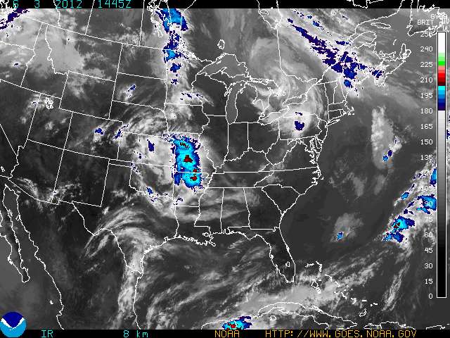
How Accurate are Weather Forecasts?


GOES Eastern US SECTOR Infrared Image

How much trust can a mariner place in a weather forecast?

Aboard ship this question is sometimes a matter of considerable importance.

 I've run across a couple items recently that address this question.

The first is from Cliff Mass Weather Blog -  the post is Extraordinary Skill for Extended Weather Forecasts

(found via Channel 14, Seattle Traffic)
 In the early days of forecasting, when our forecast models were crude and our observational resources were few, weather prediction could not get close to the theoretical limits.  But during the last decade or so, with the availability of satellite data, fast computers, and far better computer models, prediction skill has extended further and further out in time.   In the 60s-80s we were lucky to skillfully forecast out 2-3 days.  In the 90s 3-4 days.  And in the 2000s, 4-5 day forecasts were often quite skillful.  But recently, we have seen highly skillful forecasts consistently at 5-7 days, and occasionally approaching two weeks.
Here is the bottom line

So when people ask you how far into the future meteorologists can predict the weather, a good answer is:
2-3 days with excellent skill
3-4 days with moderate, but useful skill
5-6 days with marginal skill
..and occasionally skill extending out 7-10 days.
Yes...sometimes forecasts go wrong in less than a day...but is considerably less frequent than a decade ago.


The second post is from gcaptain - What is the Mariner’s 1-2-3 Rule and Should it Be Updated? - By Fred Pickhardt,

I'm not going to get into details here as I've posted on the 1-2-3 Rule before here: Guidelines For Avoiding Hurricanes At Sea

 Basically the argument is that the accuracy of hurricane track forecasting has improved and the safety margins used in the old 1-2-3 rules can, in certain circumstance, be reduced. Better to get the info  from the horse's mouth - Fred Pickhardt's post is here 


Aboard ship it is important to  monitor the accuracy of the forecasts, We don't dispose of the weather until the voyage is completed without incident. If you check  the 96hr, the 48 hr and the 24 hr forecasts against the actual  weather you can develop a sense of how accurate they are.

My experience is  that the NWS  (National Weather Service) forecasts and some other agencies  are much better then many people believe but  also it is  easy to fall into the trap of accepting them uncritically out of habit. Much like monitoring the position  of the ship to ensure it stays in safe water you should check from time to time to ensure the forecast is "on track".  How often you check depends upon the situation.

Most mariners are aware that the longer the range the forecast is the less accurate it is. The 24 hr forecast can be relied  upon more then the 48 hr and so on.  Beyond that  my rule of thumb  regarding the trustworthiness of  the forecast is it depends on the issuing agency and how complex the weather situation is. Another important considerations is how much is at stake if the forecast is inaccurate.

 I have higher trust in forecasts from the United States, Japan and Europe then some other places. I've had  the most experience in those areas and have had many opportunities to verify the forecasts. I have more trust in simple situations then complex ones, for example if there are lots of low pressure areas about I am more wary then the simpler case of a single big high pressure system.


An important question  is how much is at stake? If you lose the bet will it result in a  delay in operations or are you risking the safety of ship and crew?  In cases where you have lots of sea room it may matter little if the forecast is inaccurate as you can adjust your track as needed.  On the other hand if you are coastwise or in port your options are likely far fewer. You need to think what is the worse case scenario  and is a plan B practical?

 Plan B developed for unfavorable weather is a subject in and of  itself.

The bottom line is trust but verify - make sure you monitor the weather on a continuous basis, keep the latest forecast posted - the watch mates  should know when the next forecast is due in. Keep the old forecasts and compare them to the actual weather.

Finally, keep an eye on the barometer and the sky. - Look not to leeward for fine weather.

K.C.

UPDATE: I've tinkered with this post a couple of time and reserve the right to continue editing it in the future.

My Post Capt McWhirr on Weather Routing.

 Here is a somewhat  inane post from Freakonomics How Valid Are T.V. Weather Forecasts? The conclusion is the NWS does better then the TV weather man and that short term forecasts are more accurate then long term (no surprise there)

Lee Chesneau's Marine Weather is here - A few years back Lee wouldn't leave me alone until he was sure I understood a critical element of the 500 mb chart

Friday, February 12, 2010

Heavy weather encounter - The Satori


A U.S. Coast Guard HH-3F Pelican


In my post Parametric Rolling of a Car Carrier in Head Sea. I wrote that hidden  flaws are more  likely to be revealed in heavy weather. An example is the car ship Figaro - Inadvertent Release of CO 2 - in that case heavy weather was the trigger that caused the unintended release of CO2.

Another, less obvious example is the case of the Sailing vessel Satori  which was the sailing vessel in both the book and movie The Perfect Storm.

The Satori is: 
a short masted, heavy displacement rig. She weighs 11 tons and is designed for heavy seas. Eleven stays keep the forty foot mast secure. When the boat was built Ray requested heavy rigging to be certain that Satori could handle more severe storms.
When the owner and captain of the Satori, Ray Leonard, hove to in 40 kt winds and 30 ft seas he felt confident that his vessel was well within its limits but was unexpectedly  forced to abandon his vessel. Leonard's confidence in his vessel was not misplaced, the Satori was later recovered with little damage.   The path of failure  was not the vessel but the crew: From the story: He (the captain)  was unable to convince the crew that this motion was uncomfortable but not dangerous.
This second knockdown put the crew into a heightened state of panic. They began to insist that they call the Coast Guard for a rescue. Karen believed that the boat was going to break up any minute. The captain explained that there was no need for a rescue and that Satori had been through this before and would ride out this storm. At this point, Susan and Karen were not listening and kept insisting that they wanted to call. Ray agreed to let them call,
The Coast Guard required Capt Leonard to abandon his vessel and sent a HH-3F helicopter from Elizabeth City, N.C.  Rescue swimmer   Dave Moore went into the 30 ft seas and pulled the captain and two crew out of the water.

It is not only the vessel that encounters heavy weather, it is the vessel, crew and cargo. Operating vessels, and their crews, near limits increases risks and chances of failure, - but the path of failure may not be the one  expected.

K.C.
__________________________________________
The  son of Ray Leonard, posted a rebuttal to the book The Perfect Storm.

Friday, January 29, 2010

Parametric Rolling of a Car Carrier in a Head Sea


A 200 meter long  PCTC upbound Westerschelde River (photo by K.C.)
 

Under certain conditions a large car ship in head seas may experience sudden, unexpected, heavy rolling, a phenomena know as parametric rolling.

I have experienced this type of rolling myself while hove to aboard a 200 meter ( 656 ft) long PCTC (Pure Car Truck Carrier)  in 10 meter seas

On the 10th of March, 2008. (satellite data here) enroute from the English Channel to the Straits of Gibraltar,   about 60 miles SW of Cape Finisterre, we experienced about four hours of high wind and seas starting about noon on the  10th. When the weather first began to deteriorated at about 0800 (8 a.m.)  I began  continuously  and gradually reducing  speed. The  seas continued to become   higher and  closer together and finally, around noon, in 65 + knots of wind and with seas 10 -14 meters (33 - 46  feet), to minimize ship motion  I  turned the ship   into the seas, and reduced engine speed to bare minimum revolutions  required to maintain heading.

At noon, in spite of the huge seas, the ship seemed under control, by adjusting the engine speed between  slow  and half ahead we were able to  maintain steerage and avoid pounding, the ship was pitching heavily but without too much drama.

After about 20 minutes of successfully encountering these huge seas the ship was climbing up the face of one of the bigger seas, perhaps 12 meters, when suddenly and without warning the ship took a sharp, deep, heart stopping  roll to starboard.   This was followed by the same amplitude  roll to port and again to starboard. On the third roll the main engine lost lube oil suction and the automation  shut down the engine due to low oil pressure.

With the engine stopped the high winds caused  the heading to fall off and drifting rapidly (about 6 knots sideways) downwind,  we experienced heavy rolling in beam seas  but nothing as bad as the three big rolls experienced with head seas. Once main engine power was restored I again  turned the ship into the sea and again experienced a series of quick, heavy rolls and for the second time the main engine cut out.

After the second experience of heavy rolling while encountering head seas  I gave up on the idea of maintaining a heading into the sea and instead experimented with different tactics, settling upon running dead slow with the seas more of less on the starboard  beam with the wheel hard over to starboard,  turning up more into the sea when encountering the biggest seas by increasing engine speed and reducing revolutions, allowing the heading to fall off and slowing the ship during the smaller sets.

Over the next four hour the seas gradually diminished and by about 1600 (4pm) we began to increase speed and a couple of hours later we were on our way at close to full speed.

The ship suffered no damage with the exception of a parted wire on the  starboard accommodation ladder, there was no cargo damage. However likely not all the cargo would  stayed lashed in place had the rolling lasted much longer. Even with a crew continually tightening lashings some of the lashing on the  cargo was starting to loosen.

Luckily we escaped with minimum damage, it could have been much worse.

Lessons:

Lesson learned  - avoid heavy weather.  Hidden  flaws,  the so-called latent condition, in this case a hull shape with a propensity to roll in certain head sea conditions,  are more  likely to reveal themselves  when the ship is being tossed about in bad weather, just when  you can least afford to cope with it.

K.C

----------------------------------------------------------

- Recordings of head sea parametric rolling on a PCTC (pdf)


In February 2003, the Wallenius PCTC M/V Aida experienced sudden violent rolling in rough head sea southwest of the Azores. Roll angles as large as 50 degrees were read off the bridge inclinometer. When this incident was post-analysed it was found that the conditions, in terms of the relation of wave encounter period and natural roll period, were such that parametric rolling was the most likely cause.

- With big container ship this phenomena become more widely known after the APL China suffered huge losses after being overaken by a Pacific storm in 1998.

- Video of a cruise ship experiencing parametric rolling.


- From: Parametric rolling--the why and wherefore:

The fact that inclining at reduced stability alternates with righting at increased stability can only lead to excitation of roll if this alternation is repeated regularly and sufficiently often. This is only possible at parametric resonance, when the period of encounter approximately equals or is approximately half the effective roll period